UF announced it's monitoring Tropical Storm Nicole ahead of its predicted landfall on Florida’s east coast Wednesday night.
Alachua County is under a tropical storm watch as of 11 a.m., but no operational changes are expected for Gainesville or the UF campus, according to UF’s most recent Monday weather update,. Power outages, downed trees and damage to structures are possible in Alachua County, according to a 10 a.m. Alachua County weather update.
There are no further updates from UF as of 1 p.m. Tuesday, said Cynthia Roldan, a UF spokesperson.
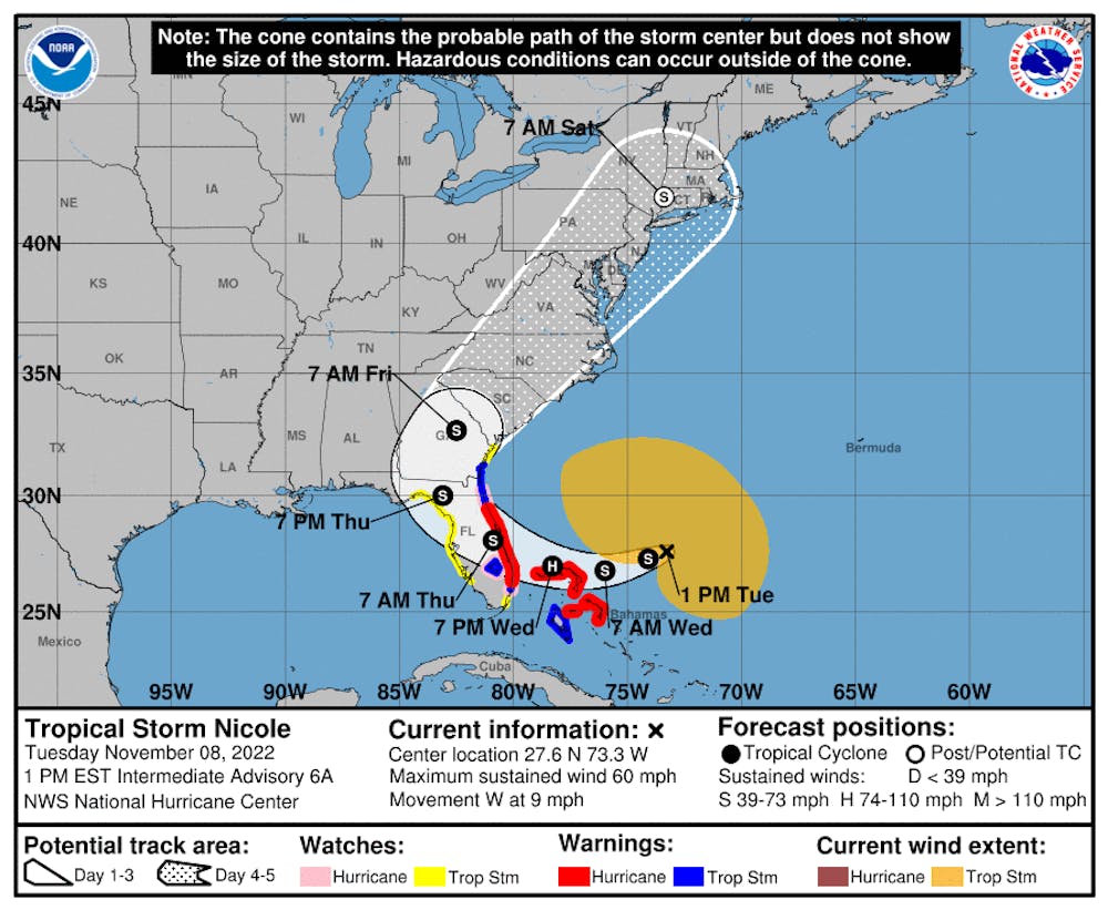
The storm is moving northwest at 9 mph, and it’s located around 460 miles east of West Palm Beach, where predictions expect it will make landfall. Gainesville is currently inside the cone of uncertainty, meaning the center of the storm will stay within the cone for roughly two out of every three forecasts. The storm’s maximum sustained winds are near 50 mph.
The tropical storm is expected to intensify into a hurricane over the Bahamas by Wednesday at 7 p.m. The National Hurricane Center predicts the storm will weaken into a tropical storm by 7 a.m. Thursday as the center of the storm makes landfall over the east coast, impacting cities such as West Palm Beach, Daytona Beach and Jacksonville.
The probability Alachua County will experience tropical storm winds over 39 mph is expected to be between 60% and 80%, according to NHC.
However, the NHC's latest update as of 10 a.m. advises not to focus on the exact track of the storm because Nicole is expected to affect much of the Florida peninsula. As of 10 a.m. Tuesday, NHC predicts the storm will produce between three to five inches of rain with a maximum of seven inches in north central Florida.
Much of Florida’s east coast has been put under a hurricane warning, with strong wind gusts expected later today. The west coast of Florida has also been put under tropical storm watch.
Gov. Ron DeSantis placed the following counties under a state of emergency: Brevard, Broward, Charlotte, Citrus, Clay, Collier, DeSoto, Duval, Flagler, Glades, Hardee, Hendry, Highlands, Hillsborough, Indian River, Lake, Lee, Manatee, Martin, Miami-Dade, Nassau, Okeechobee, Orange, Osceola, Palm Beach, Pasco, Polk, Putnam, Sarasota, Seminole, St. Johns, St. Lucie, Sumter and Volusia Counties, according to an executive order issued Monday.
A three to five inch storm surge is also expected along the east coast, according to the Florida Public Radio Emergency Network.
The Florida Department of Emergency Management encouraged Hurricane Ian survivors to apply for FEMA and for Floridians to review their disaster preparedness ahead of the storm.
NHC’s next update will be available at 4 p.m. Tuesday.
Contact Fernando at ffigueroa@alligator.org. Follow him on Twitter @fernfigue.
Fern is a junior journalism and sustainability studies major. He previously reported for the University and Metro desks. Now, he covers the environmental beat on the Enterprise desk. When he's not reporting, you can find him dancing to house music at Barcade or taking photos on his Olympus.


